This is a Shed post. If you’re new to Wait But Why and don’t know what the Shed is, it’s a place where I post things I find on the internet. This is different than a Mini post, which is a WBW original post, just a short one. You can check out the whole Shed here.
___________
My entire morning was just derailed when a reader named Stuart emailed me a delicious thing that Google has done, called Google Earth Timelapse.
Using high-resolution satellite photos, Google has created a timelapse of the planet’s entire surface that brings you from 1984 to 2016 in four seconds. Google explains:
We sifted through about three quadrillion pixels—that’s 3 followed by 15 zeroes—from more than 5,000,000 satellite images … We took the best of all those pixels to create 33 images of the entire planet, one for each year. We then encoded these new 3.95 terapixel global images into just over 25,000,000 overlapping multi-resolution video tiles.
They have compiled the greatest hits into a 40-minute YouTube playlist, which I may or may not have watched in full.
I plucked out my favorites from the playlist. Here they are (best in full-screen):
One fun category is expanding cities. Some cities were already super developed in 1984 and don’t show super-dramatic changes. Like New York:
Same story with Downtown San Francisco—though you can see plenty of development in the form of the little white dots of new building roofs being sprinkled on top of an already-dense landscape. Also note the birth of an Oakland-San Francisco bridge:
But in cities that have seen great development in the past 30 years, the timelapses are mesmerizing. To an alien watching Earth from afar, city development would look like the spores of a virus spreading across the surface.
Here’s Bangkok:
Beijing:
Here’s Cairo, and a new city called New Cairo City forming on the right side:
Chinese cities are especially crazy. Like Chengdu:
Hefei:
Shanghai did this between 1990 and 2010:
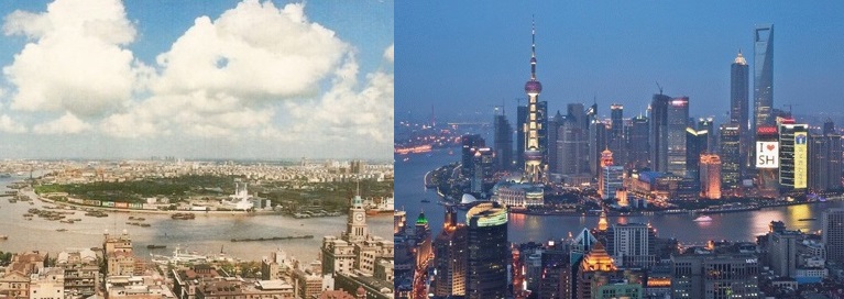
Which looks like this from above:
Here’s Kuala Lampur:
And Dubai, which grew like a normal city until around 2000 when things got silly:
And then there’s Al Khiran Pearl City in Kuwait, where they turned a few dozen miles of beachfront property into like 1,000:
Another category I like is farmland. The annual crop fluctuations produce cool looking timelapses. Like this farmy area of Cologne, Germany:
Or even delightful timelapse of rural California:
Or this part of Nebraska, which in timelapse looks like static on a TV:
This is a cool one from Bolivia that shows farm squares coming into existence over time:
Not really sure what’s going on here in Rondonia, Brazil, but it’s cool looking:
In Zwenkau, Germany, the last place in every alphabetical list, it looks like either the Germans have intentionally created a bunch of lakes, or the lakes have formed as an effect of their farming:
I think this timelapse of Madagascar is what deforestation looks like from above:
Glaciers are also cool in timelapse. Glaciers are flowing rivers of ice. They normally move so slowly they just seem static to our eye, but timelapse reveals their movement:
This one of the Ross Ice Shelf in Antarctica shows the ice melting over time:
Water’s cool too. Apparently there are a lot of lakes out there drying up. Like Utah’s Great Salt Lake:
Or Kazakhstan’s and Uzbekistan’s Aral Sea, which is drying up as a result of Soviet farming efforts and causing an ecological disaster:
And Iran’s Lake Urmia is almost gone:
Timelapses also show how rivers slither around the landscape:
And it sucks when you build your city on a river and then the river gets bored and leaves:
And finally, here are a couple that show the staggering effect of a dam:
Again, the whole playlist is here, and below, you can look at any place on the Earth you want and press play to watch it timelapse (if it’s not working, check it out here).